8th Sussex Geek Dinner

Last night I attended the 8th Sussex Geek Dinner (organised by Simon Harriyott) where Mikel Maron gave a great talk about his involvement with the OpenStreetMap project (they plan to finish mapping Brighton by Spring, and the entire Isle of Wight was completed last year).

The talk was great, beer was drunk and I had good chats with a bunch of like-minded geeks about our ShowMeDo. All in it was a great evening and I look forward to the next!

Here you can see the completed Isle of Wight map, sadly the current Brighton map isn’t yet online Brighton interactive map here (thanks SteveC):
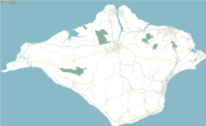
Isle of Wight by OpenStreetMap

5 Comments

  • Hi Brighton is up and browsable :) http://www.openstreetmap.org/index.html?lat=50.8278639837955&lon=-0.15719255244982203&zoom=12
  • [...] I really enjoyed last night’s geek dinner (as did Jane, Clive and Ian). Mikel Maron spoke engagingly about OpenStreetMap, and answered loads of questions. Looking round the room, everyone was enraptured for the hour or so that Mikel spoke. I was particularly interested to hear about the data collection - walking, cycling or driving around with a GPS unit and noting the street names and features. It sounds great fun, and I’m hoping to do some myself in Uckfield, as nobody else has yet, judging by the current map. [...]
  • Pingback : Yet Another Blog
    Sussex Dinner
  • It is amazing how much people rely on these maps. Did you catch the BBC news item about 2 months ago about the village with an impassable road, that the "tom-tom" system was directing people down? There was a big stream that went accross it during rainy periods, that meant drivers would get stranded if they tried to cross. However, despit 2 warning signs, people kept on trying. A couple of the local villagers starting charging for towing people out, making a nice supplemental living from it. When asked why they had ignored the warning signs and driven down the road anyways, the response was always 'my navigation system told me to'. One can hope they would only stop for a bridge out sign, but now I'm not sure!!
  • I have heard about that story before, and I see this one about caravans and narrow lanes: http://news.bbc.co.uk/2/hi/uk_news/wales/north_west/5072450.stm Amusing stuff! I'm an ex-boy scout, I tend to navigate via Ordnance Survey maps, I feel rather lost without contours :-) Ian.